
|
Find out more about the areas of Otway State Forest that are scheduled to be clearfell logged over the next three years. |
|
Search forest areas scheduled for logging using one of the options below,
or Search by: The following information contains lot of jargon. See Explanation
of Terms |
Year Scheduled: 02/03 Size: Roadline Woodchip: 57.2917%
Log Grades(m3): Woodchip: 1100 B+: 220 C: 400 D: 180 Black Wood: 20
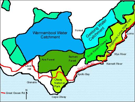
Known Threatened Values: Geelong Domestic Water Supply Catchment (Gazetted); High natural landscape values within catchment;
Year Scheduled: 03/04 Size: 23(ha) Woodchip: 58.1395%
Log Grades(m3): Woodchip: 5000 B+: 1000 C: 1800 D: 700 Black Wood: 100
Known Threatened Values: Geelong Domestic Water Supply Catchment (Gazetted); High natural landscape values within catchment; Requires new road within domestic water supply catchment;
Year Scheduled: 02/03 Size: 33(ha) Woodchip: 64.3678%
Log Grades(m3): Woodchip: 2800 B+: 500 C: 700 D: 300 Black Wood: 50
Known Threatened Values: Geelong Domestic Water Supply Catchment (Gazetted); High natural landscape values within catchment;
Year Scheduled: 04/05 Size: Roadline Woodchip: 58.8235%
Log Grades(m3): Woodchip: 1000 B+: 200 C: 200 D: 300 Black Wood: 0
Known Threatened Values: Geelong Domestic Water Supply Catchment (Gazetted); Tourism Values; Requires new road within domestic water supply catchment;
Year Scheduled: 02/03 cont. Size: 32(ha) Woodchip: 67.7340%
Log Grades(m3): Woodchip: 5500 B+: 600 C: 1500 D: 500 Black Wood: 20
Known Threatened Values: Geelong Domestic Water Supply Catchment (Gazetted); High natural landscape values within catchment;
Year Scheduled: 02/03 Size: 21(ha) Woodchip: 63.0631%
Log Grades(m3): Woodchip: 3500 B+: 600 C: 900 D: 500 Black Wood: 50
Known Threatened Values: Geelong Domestic Water Supply Catchment (Gazetted); High natural landscape values within catchment;
| Note: Carryover coupes are areas of forests that
were not logged, or logging was not completed in the logging season scheduled.
They are available for logging. |
All data sourced from Department of Natural Resources and Environment / State of Victoria documentation. For maps that exact areas to be logged "coupes" , see Government Website.
Disclaimer
Otways Logging WHERE? php programming by Web Necessities. Database by Nikki Parker
/ OREN