State Government accepts almost all VEAC 'Final Recommendations' for the Otways
On Friday the 10th June 2005, The Premier of Victoria Steve Bracks along with Environment Minister John Thwaites announced Otway legislation will be introduced into the Victorian State Parliament to create a new 102,500 hectare National Park to be called the "Great Otway National Park". This announcement was made at the Moggs Creek picnic ground.
The State Government's announcment means almost all of the Victorian Environment Assessment Council's (VEAC) 'Final Recommendations' have been accepted (95% acceptance) including almost all of the VEAC recommended National Park boundaries.
See State Government & OREN Press Releases.
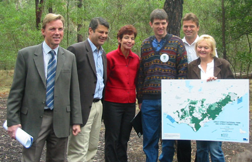
John Thwaites (Minister for the Environment and Deputy Premier), Premier
Steve Bracks, Julie Hansen (former Mayor, Surf Coast Shire Council), Simon
Birrell (OREN), Michael Crutchfield (Member for South Barwon), and Elaine
Carbines (Member of the Legislative Council) holding a map of the new
Great Otway National Park at the Moggs Creek Picnic Ground.
To see a map of the Great Otway National Park see this link to the VEAC website.
The Otway State Forest, which totals 92,000 ha, will be disbanded with about 52,500 ha (57%) going into the Great Otway National Park and about 1,900 ha (2%) going into the Jancourt Nature Conservation Reserve.
The rest of the Otway State Forest will become a Forest Park legislated under the Crown Lands Reserves Act where logging will be banned when current woodchip and sawlog licences expire in June 2008.
What has been protected?
Key areas of State Forest are now included in the new Great Otway National Park. These areas include:
- all Rainforest Sites
of Significance,
- the East and West
Barwon Catchments which together make up the bulk of the Otway Geelong
water supply,
- the Arkins Creek catchment
(and Link Track) which makes
up critical part of the Warrnambool water supply catchment,
- and the Aire Heritage River corridor.
Many areas where protests against logging occurred are now in the new Great Otway National Park; these include the forests of;
- Riley's Ridge,
- Cumberland river,
- Wye river,
- Sabine Falls,
- Wilddog Ridge
- and forest in the Aire river catchment at places such as Ciancio Creek and Halls Ridge.
Less well known but critically important areas in the far Western Otways
will also be protected by the National Park. These areas include the Carlisle
Heathlands and significant remnant woodland forests left over from the
Heytesbury Land Settlement Scheme where about 43,000 ha of forest was
cleared for dairy farming between of 1957 and 1970.
Were has all the disbanded Otway State Forest gone?
The following is an approximate break up of the Otway State Forest (OREN estimates only).
National Park 52,530 ha (57%)*
Nature Conservation Reserve 1,900 ha (2%)
Forest Park 37,600 ha (41%)#
Total Otway State forest 92,030 ha (100%)
*Note: in the Western Otways there is approximately 3,500 ha of Carlisle Heath within the Otway State Forest that is classified as SPZ under the West RFA. This will be included in the expanded Otway National Park. The Carlisle Heath area has no forest of commercial value for logging and represented about 4% of the Otway State Forest total.
#Note: about 4000 ha of proposed Forest Park within
the Geelong water supply catchment has an informal ban on logging which
began after the state election in November 2002.
Don't know the meaning of a word? Check the glossary.